Tuesday, June 10, 2003
The big picture
My wife Leigh and I were going to rendezvous at the mall, so in order to avoid confusion (which is easy when you have four kids...) we looked at this aerial photo of the mall and decided exactly where we would meet:
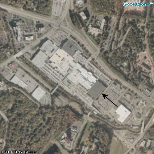
Photo of Crabtree Valley Mall in Raleigh, NC provided by MapQuest
The place where we looked at the photo was MAPQUEST. The very nice thing about the Mapquest aerial photos is that you can find your general location using the normal roadmaps that MapQuest is famous for, and then click the Aerial Photo tab to switch over to photo mode. You can look at your house, your business, your school, the mall... Anything in town. Not all parts of the U.S. have detailed aerial photos, but most parts have something. The Aerial Photo tab is located just above the map.
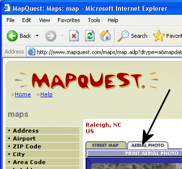
[Hint: For towns that don't seem to offer the aerial photo tab, you can start in Raleigh, NC (or any nearby city that does offer the tab), zoom out, and then zoom in on the location you want. The Aerial Photo tab will follow.]
- 05/01/2003 - 06/01/2003
- 06/01/2003 - 07/01/2003
- 07/01/2003 - 08/01/2003
- 08/01/2003 - 09/01/2003
- 09/01/2003 - 10/01/2003
- 10/01/2003 - 11/01/2003
- 11/01/2003 - 12/01/2003
- 12/01/2003 - 01/01/2004
- 01/01/2004 - 02/01/2004
- 02/01/2004 - 03/01/2004
- 03/01/2004 - 04/01/2004
- 04/01/2004 - 05/01/2004
- 05/01/2004 - 06/01/2004
- 06/01/2004 - 07/01/2004
- 07/01/2004 - 08/01/2004
- 08/01/2004 - 09/01/2004
- 09/01/2004 - 10/01/2004
- 10/01/2004 - 11/01/2004
- 01/01/2005 - 02/01/2005
- 02/01/2005 - 03/01/2005
- 03/01/2005 - 04/01/2005
- 04/01/2005 - 05/01/2005
- 05/01/2005 - 06/01/2005
- 06/01/2005 - 07/01/2005
- 07/01/2005 - 08/01/2005
- 08/01/2005 - 09/01/2005
- 09/01/2005 - 10/01/2005
- 10/01/2005 - 11/01/2005
- 11/01/2005 - 12/01/2005
- 12/01/2005 - 01/01/2006
- 02/01/2006 - 03/01/2006
- 03/01/2006 - 04/01/2006
- 04/01/2006 - 05/01/2006
- 05/01/2006 - 06/01/2006
- 06/01/2006 - 07/01/2006
- 07/01/2006 - 08/01/2006
- 08/01/2006 - 09/01/2006
- 09/01/2006 - 10/01/2006
- 10/01/2006 - 11/01/2006
- 11/01/2006 - 12/01/2006
- 12/01/2006 - 01/01/2007
- 01/01/2007 - 02/01/2007
- 02/01/2007 - 03/01/2007
- 03/01/2007 - 04/01/2007
- 05/01/2007 - 06/01/2007
- 07/01/2007 - 08/01/2007
- 09/01/2007 - 10/01/2007
- 07/01/2008 - 08/01/2008
![]()
